From High Street East, the streets leading uphill to the south of the river head towards what remains of ‘Old Sunderland’, the original parish that gives its name to the modern city. The corner of Church Street, where it intersects with High Street East, now has a mural of local hero Jack Crawford painted on the gable end of the building. You can find out more about Crawford here.

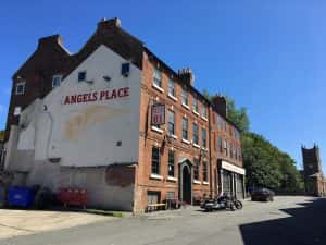
Church Street contains two of the early eighteenth century merchants’ houses that hint at the grandeur of this area at that time. The building (built in 1711) that is first visible from High Street East has “Angels’ Place” painted on its gable wall. This is the home of the Sunderland Hell’s Angels, and their bikes are often found gleaming in the sunshine in the street outside.
The area around Holy Trinity Parish Church is particularly interesting. Holy Trinity itself served as the parish church for Sunderland. It was built in 1719 on the edge of the town moor, and its churchyard contains the remains of many Sunderland notables, although only a few graves remain visible. The Rain’s Eye Plan shows the church’s position in the 1780s, with the Freeman’s Moor to the south and the crowded streets of the docks to the north. This also shows the original position of the rectory, before it was moved further to the east.
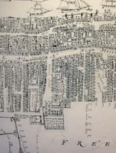
Detail from Rain’s Eye View, courtesy of Sunderland Antiquarian Society.
The red brick church building is in the classical style of the Georgian period, marking a clear distinction between the medieval St Michael’s of Bishopwearmouth and St Peter’s at Monkwearmouth. The church is thought to have been designed by William Etty of York (1675-1734) and uses bricks made of clay dug from the town moor. The tower originally had a cupula but now has just the four pinnacles.

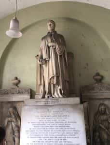
The interior was designed for use beyond that of religious worship, and was a seat of local government, acting as the old Sunderland Council Chamber and library. The deconsecrated church building is now a venue for concerts and other events. The graveyard is now largely undulating grass, but two notable graves remain: the headstone for Jack Crawford, ‘Hero of Camperdown’, and the memorial for the much-admired rector, Robert Gray. There is also an imposing statue of Gray in the entrance porch of the church.
You can read more about Gray here. The interior is noted for its original features of Corinthian columns and the bow-shaped gate that swings open to allow access to the alter. Sir Cuthbert Sharp’s poem on the loss and grief associated with churchyards can be found here.
Reverend Robert Gray’s name is recorded on various blue plaques around the Town Moor at this point. The churchyard itself is recorded as ‘Gray Memorial Gardens’, with Gray’s tomb being one of only a handful that remain visible (another is the memorial stone to Jack Crawford). On the far side of the Town Moor is a plaque to the Gray’s School, which was an infants’ school Gray set up in 1834. Gray also preached in St John’s church which stood at the side of the Town Moor that runs along Prospect Row.

View of St John’s Church courtesy of Sunderland Antiquarian Society.
St John’s church came about to ease the overcrowding in Holy Trinity, and was built to accommodate an additional 1,200 parishioners. The church here in Prospect Row was similar in style to Holy Trinity, but less ornate in terms of a more restrained stonework. Like Holy Trinity, it had a square tower. The foundation stone was laid in 1764 after a grand Masonic procession. The main force behind the building of this church was John Thornhill (1720-1802), after whom the church was named. Thornhill came from a wealthy family of merchants who owned Thornhill Wharf and whose house on the outskirts of Sunderland gave its name to that area. The Thornhills also had major shares in Indian slave plantations. John Thornhill was a divisive figure, famously described by local historian James Corder as “a curious mixture of piety, public spirit, conceit and fraud’. The family moved out of Sunderland to North Yorkshire in the early nineteenth century, but their legacy lives on in the various street names and district of Sunderland. Thornhill’s input into the church’s design included a gallery for his family and also a parallel gallery for the soldiers stationed at the barracks which were located on the edge of the Town Moor. Apocrophally, on his death in 1802, Thornhill was buried beneath the alter at St John’s. The church itself was demolished in 1972, although no trace of Thornhill’s remains were found at that time.
Prospect Row on the northern edge of the Town Moor is also the location of the building that once held the Prospect Row Mission, which had been set up in 1885 as a children’s mission. Now a gym and community centre, this building is the first in the world to be purposely fitted with outward-opening doors as a direct response to the Victoria Hall disaster. See here for more information about the Victoria Hall Disaster.
Viewed to the south of the churchyard is an imposing building that was the Boys’ Orphanage but is now private flats. The original purpose of the building is found engraved in the stone pillar of the gateposts.
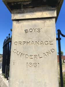
It was was designed in the Italian Renaissance style that was fashionable in the 1860s in the wake of Prince Albert’s design for Osborne House on the Isle of Wight (1845-51). The orphanage building in Sunderland was designed by Childs and Lucas, who actually came second in the competition that had been held for the design of the building, but whose design was favoured by the planning committee. The orphanage was intended for the care and education of the orphans and illegitimate sons of the Sunderland mariners. The building was primarily funded from selling access rights on the Town Moore to various railway companies that ran to the docks in Hendon. Queen Victoria herself also donated £100 towards it construction, and asked to see the architectural plans.
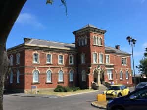
The orphanage was built over two stories with a central tower in the Renaissance style. The tower offers a view over the port and sea. Construction was of bricks made on the Town Moor, just as the churches of St John’s and Holy Trinity had been. It was started in 1856 and finally opened on 1 October 1860, when it could accommodate 40 boys. The link with their fathers was maintained through the uniform designed to emulate a sailor’s, and the skills they learnt were intended to train them for a seafaring career.
This seafaring tradition in Sunderland can also be seen in the buildings at the bottom of the churchyard, in Trafalgar Square. Both Old Sunderland and Bishopwearmouth had almshouses for aged seamen. In Bishopwearmouth, these were located beyond St Michael’s church in the street that still bears the name Maritime Terrace. For more information, see here. In Old Sunderland, the almshouses were built in 1840 and form a neat square called after the famous sea battle of 21st October, 1805.

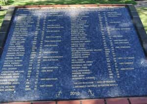
In 2010, a large granite plaque was erected in the centre of this square to explicitly commemorate the 76 Sunderland sailors who were present at that battle.
The ‘square’ is actually a three-sided terrace bordering a neatly kept garden. There is a flagpole secured with mooring ropes by the entrance to this square, a reminder of the occupation of the early residents of Trafalgar Square.
Further up the lane, back towards Holy Trinity, stands one of the earliest school buildings left in Sunderland: the Donnison School. This was established from an endowment left in the will of the widow Elizabeth Donnison in 1764. She had stipulated that this school should provide a free education for ‘36 poor girls’, teaching them reading, writing, arithmetic, and needlework. The school opened in 1798 and was extended by another wealthy benefactor, Mrs Elizabeth Woodcock in 1827 when the main part of the current building was added. Like Holy Trinity Church, Donnison School is built using red bricks made from clay excavated from the Town Moor.

Trafalgar Square, Donnison School and Holy Trinity Church all form one side of the lane with the workhouse on the other. This photograph from the 1880s shows the workhouse building to the left with the Donnison School at the side of the lane to the right.
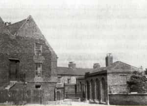
Image courtesy of Sunderland Antiquarian Society.
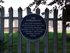
Long since demolished, this workhouse dated from 1740 and housed 600 people. The site also encompassed a pin factory, sailmaker’s loft and the second hospital. A blue plaque marks the site today.
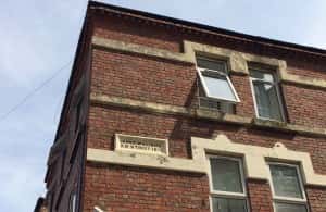
There is still a hospital building a short distance away from here, the Freeman’s Hospital at the southernmost end of James Williams Street.

This street was constructed during the 1870s’ redevelopment of Sunderland and was named after Councillor James Williams (1811-1868). Williams was a leading temperance reformer who also campaigned for better sanitation and the abolition of bridge tolls. He was also instrumental in starting the first free lending library in Sunderland. The James Williams Board School stood on the eastern side of the street, whilst the Freeman’s Hospital that still stands is on the opposite side of the road. The original hospital, built in 1719, stood in Church Street but moved to the James Williams Street site when the new Rectory was built on its former site. The redbrick building dates from 1876 and, although now flats, still carries the plaque marking this earlier use. At the northern-most end of the street, the stone name plate for it is still clearly visible.
Pheonix Lodge in Queen Street East is the oldest surviving Freemason Temple in the UK. It was designed by John Bonner in 1785 to replace an earlier lodge that had been destroyed by fire. The Palladian style to the front of the building carries the Masonic symbol, a recent addition. The building is now drawfed by the towerblocks around it, built in the 1960s and 70s to house the residents who had previously lived in the slum conditions of the decaying East End housing.

The interior of Pheonic Lodge is usually closed to visitors, but the public are welcomed in during annual Heritage Open Days. This reveals the original main hall, with features such as the chair in the east end of the hall which came to Phoenix Lodge in 1785 from an older Lodge in Newcastle. This link can still be seen today in the Newcastle city logo surmounting the chair.

The Lodge is built on the site of an even older building that was the Golden Lion Hotel. The dining hall of the current building is in the shell of the stable block, and the main hall is built over a cellar that is on the site of the pub’s bowling green. The cellar itself is constructed of local brick and rubble, with the joists coming from wood gleaned from the ship yards that would have been in close proximity by the late eighteenth century. Many of these timbers has previously been used on ships, such as masts. As a result, it is still possible to see the ‘witches marks’ on several of these. Witches marks are also known as ‘apotropaic markings’, from the Greek apaotropaios, meaning to ‘turn away (evil)’. The overlapping Vs are known as marion marks, and are believed to refer to the Virgin Mary. It is thought that these marks were invocations to the Virgin Mary to protect the ship where the marks were to be found. Witch marks are found in various forms in all types of buildings around the country. The date back to medieval times, but continued to be used until the early nineteenth century, when there was a belief in witchcraft and the supernatural and the use of magical symbols and ritual objects was a part of everyday life.

The crowded streets around the old Sunderland area has once been affluent but by the 19th century were in varying states of decay. The 1851 street map of Sunderland, as drawn up by Thomas Meik and Robert Morgan (both engineers for the River Wear Commissioners at this time) shows the narrow terraced streets around the docks. The section of the map shown below is that area at the furthest east point, with Holy Trinity Church at the bottom left corner, and St John’s at centre right.

Image courtesy of Sunderland Antiquarian Society
As is typical of port areas, the narrow streets contained innumerable taverns and were famous for their hospitality for the ever-changing community of sailors and tradespeople. The particular delights of the taverns and population are recorded in this poem collected by Joseph Ritson in the eighteenth century, where it names a landlady, Mabel Rob, in Silver Street. More particularly, the prostitutes who worked around the docks are recorded in this poem from the 19th century, which is one of many that celebrates the relationship between the sailor and the ‘pretty girls’ who frequented the streets at night.
This photo from the early twentieth century shows a pub on the corner of Silver Street where it intersected with Prospect Row.
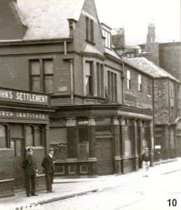
Image courtesy of Sunderland Antiquarian Society.
The poverty and squalor of this area throughout the 19th century and into the 20th century is recorded in photographs held by Sunderland Antiquarian Society. Somehow, the streets continued to be inhabited well into the 20th century, defying Victorian attempts at ‘improvement’ that stretched along the western end of High Street East, and even the Luftwaffe bombing raids that flattened so much of the rest of the area around the docks. This photograph below, taken in 1953, shows the general state of dilapidation in the still-inhabited houses. The roofs are largely untiled, with cheaper asphalt acting as a covering in many cases. Broken windows are patched up but still have the rudimentary features of respectability in their white net curtains behind. To the right, the former grand houses of the 18th century can still be seen, but in a similar state of disrepair.

Image courtesy of Sunderland Antiquarian Society.
Eventually, in the 1960s, the streets around Holy Trinity Church were demolished in a massive slum clearance. They were replaced by tower blocks that carried the names of some of the former streets, such as Burleigh Garth which covered the area once occupied by Silver Street and Burleigh Street. In turn, these were demolished some twenty years later, replaced by a mixture of tower blocks and modern terraces.